Bhu Naksha 2026 — Check Land Map & Records Online State-Wise
Updated: 26-04-2026 at 5:30 AM


1k


Property records and ownership of land have always been a major component of the administrative and economic system in India. Nevertheless, conventional land record systems used to be complex, paper-based and prone to errors, disputes and lacks transparency. Making the land record online check process extremely difficult for citizens. To obtain land maps or verify Khasra Khatauni details, several visits to government departments were necessary, which were time-consuming and inefficient.
The Government of India had to deal with these issues and modernise land record management through the introduction of digital initiatives such as the BhuNaksha as part of the larger Digital India programme. BhuNaksha is an online system that allows citizens to access digital land maps through which they can access plot boundaries, survey details and land information online without physical interference.
It is linked to state land record portals and collaborates with systems such as Bhulekh to provide detailed information on land issues. Recent developments have seen several states in India implementing BhuNaksha. State-specific websites such as Bhu Naksha UP, Bhu Naksha Bihar, Bhu Naksha MP and Bhu Naksha Rajasthan have greatly enhanced accessibility and transparency of land records.
In this article, we are going to discuss all about BhuNaksha in detail, its meaning, features, benefits, its availability by state, how it is used and how it enhances transparency and governance in land management.
Bhu Naksha Overview
The table below highlights the key insights and essential details of the BhuNaksha system in India:
| Particular | Details |
|---|---|
| System Name | BhuNaksha (Digital Land Mapping System) |
| Developed By | National Informatics Centre (NIC) |
| Programme | Digital India Land Records Modernisation Programme (DILRMP) |
| Purpose | Digitisation of cadastral land maps |
| Type of Data | Land boundaries, plot details, and ownership data |
| Accessibility | Online via state portals like Bhu Naksha UP, Bhu Naksha Bihar, etc. |
| Technology Used | GIS (Geographic Information System) |
| Integration | Linked with the Record of Rights (RoR) databases |
| Coverage | Implemented in 25+ States/UTs |
| Users | Citizens, farmers, buyers, government authorities |
Also Read: AnyRoR 7/12 Gujarat Land Records Online.
Historical Context Of BhuNaksha
Land records in India before the introduction of BhuNaksha were mainly maintained manually using paper maps and registers. This system posed several problems, such as inconsistency of data, time lag in updating it, and land disputes were common.
In a move to modernise land records, the Government of India initiated land record modernisation projects, including the National Land Records Modernisation Programme (NLRMP), which was subsequently incorporated into the Digital India Land Records Modernisation Programme (DILRMP). It was meant to digitalise the textual and spatial land records to enhance transparency and minimise disagreements.
-
Previous systems were only interested in digitalising textual information, such as ownership records, and the maps remained the same and were not easy to revise.
-
To fill this gap, BhuNaksha was launched, providing a digitisation of defined large-scale maps, connecting them to ownership data, and forming a single land information system.
-
The platform was also developed to include the simplest map scanning tools to more sophisticated GIS-based ones, which enabled editing, subdivision, and real-time updates.
-
It has now been supporting mega projects such as ULPIN and land parcel mapping, which have assisted in enhancing land governance and investment planning.
What Is BhuNaksha?
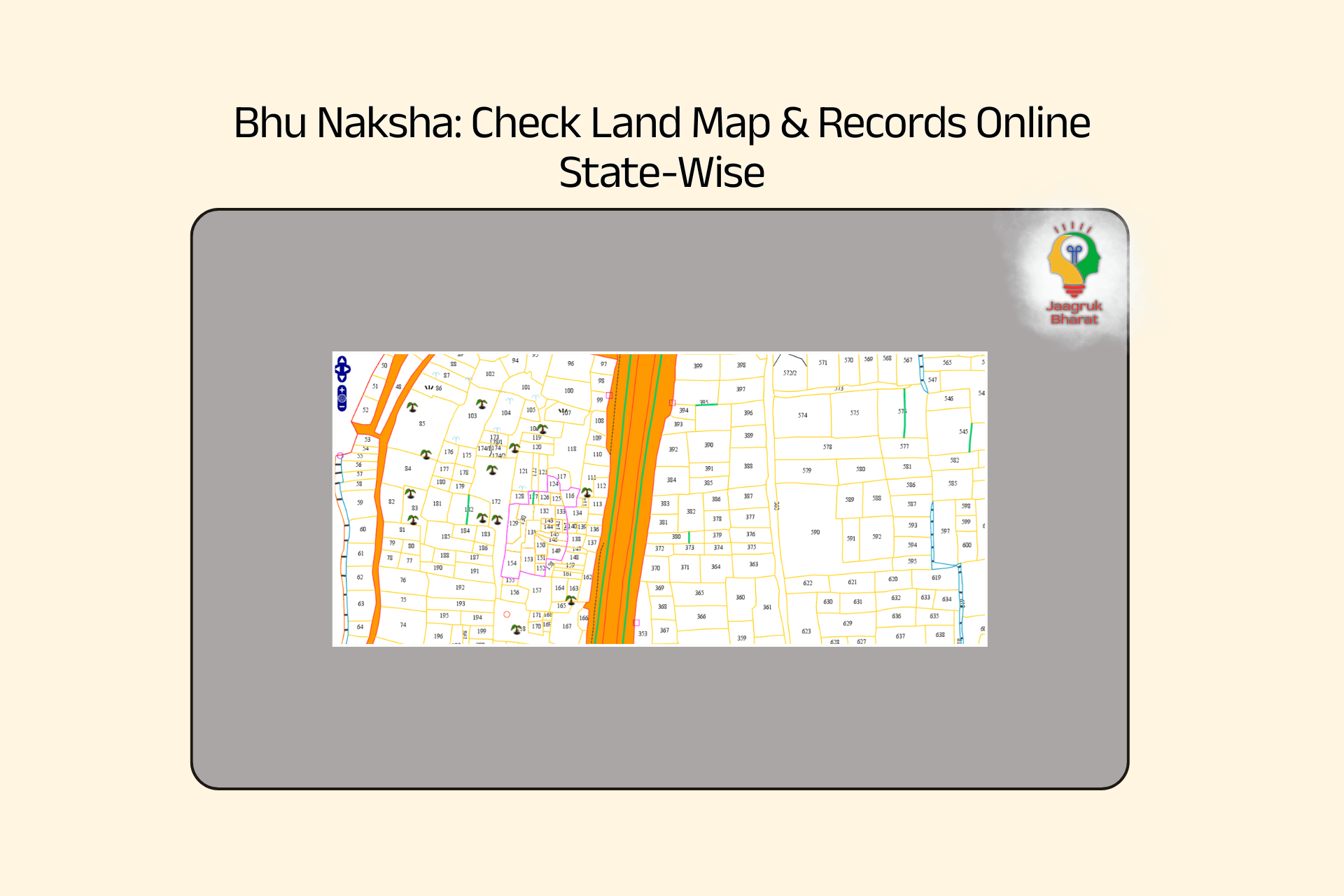
BhuNaksha is an online service which enables users to access a cadastral map (a land map) on the internet, where they can access data regarding land parcels, land boundaries, and subdivisions of plots. It is created to computerise the land mapping systems and ensure that they are easily available to the people in a transparent and user-friendly way.
This simplifies the process of land owners, purchasers and government to comprehend the patterns of land distribution and ownership. It is usually connected to state-specific land record systems, enabling users to cross-reference the map data with ownership information on Bhulekh portals.
Features Of BhuNaksha
Before the utilisation of BhuNaksha, one should be aware of the strong functionalities that have made it a stable digital land mapping system in India.
-
Coded in Open-Source: BhuNaksha is coded on open and free software, which makes it cost-effective, flexible, and has the capability of constant improvement without reliance on costly proprietary systems.
-
Support on Multiple Platforms: The system is compatible with Windows, making it user-friendly on various government configurations and devices without any compatibility problems.
-
Centralised and Distributed Architecture: It is able to be run out of a central server, or through district-level servers, which enables flexibility depending on the connectivity and infrastructure in other states.
-
Web, Desktop and Mobile Access: BhuNaksha can be accessed via browsers, desktop and mobile devices, making it convenient for both the officials and the citizens.
-
Easy Viewing, Responsive Design: The site automatically adapts to a variety of screen sizes, so it can be easily used on smartphones and tablets.
-
Connection to Land Records (RoR): BhuNaksha links with Record of Rights (RoR) databases, so there is an accurate synchronisation of map data and ownership details.
-
Plot Division and Subdivision Tools: This allows users to subdivide a piece of land digitally into several parts, which can be helpful when undertaking a mutation, sale or inheritance.
-
Several Plot Editing Alternatives: Editing, merging, and subdivision of many plots can be performed simultaneously in one operation, which is hectic in large-scale land updates.
-
Distance Measurement and Area Calculation: It is a set of precise measurement devices that take into account local units and scales and can be used to assess land more efficiently.
-
Printable Maps of any scale: Users may create and print village maps/plot maps in varying scales as needed to be used either officially or personally.
-
Geo-Referencing of Old Maps: Geo-referencing tools can be used to convert paper maps into digital maps to enhance accuracy and use.
-
Audit Trail and History Tracking: All the changes performed on land parcels are documented, and land records management is transparent and accountable.
-
Bulk Data Import and Validation: Bulk files like shape files and survey data can be uploaded and checked to make sure that the maps and records are consistent.
Objectives Of BhuNaksha
Before understanding how BhuNaksha work in practice. It is important to look at the broader objective behind its implementation:-
-
Digitisation of Land Maps and Minimisation of Paperwork: The main aim of BhuNaksha is to digitise the conventional paper-based cadastral maps to digital forms that can be easily accessed and updated.
-
Improving Transparency in Land Ownership: Another important reason to implement BhuNaksha is to have a transparent and accurate graphical description of land parcels, boundaries, and ownership.
-
Decreasing Land Disputes and Legal Wars: Land disputes are a significant problem in India, often due to poorly defined boundaries or outdated records. BhuNaksha is supposed to reduce such conflicts by ensuring that verified and standardised land information is publicly accessible, where ownership and boundaries can be easily verified.
-
Supporting Efficient Land Management and Planning: The system offers credible and well-organised information that can be utilised by government authorities in urban planning, infrastructure development and management of resources. Proper land mapping assists in making correct decisions and in ensuring that the development projects are properly carried out.
-
Marketing Digital Governance Under Digital India: BhuNaksha is a component of the Digital India project, which aims to enhance governance by using technology. Through digitalisation of land records and their incorporation into other systems, it encourages quicker service delivery, minimises corruption, and citizen engagement in the governance processes.
-
Integration with Modern Land Record Systems: Another goal is to integrate spatial data (maps) with textual land records like the Record of Rights (RoR). This forms a cohesive system in which ownership information and geographical information are connected to ensure consistency and reliability of the land information.
Also Read: Decoding Farmer Welfare: MSP Reforms, And Way Forward
Benefits Of BhuNaksha
With the introduction of BhuNaksha, there are several advantages to both citizens, the government authorities and the real estate industry. The knowledge of these benefits underscores the significance of this online program.
-
Better Transparency and Fraud Reduction: BhuNaksha offers visual land maps which have direct links to the official records, thus facilitating easier ownership and boundary checks. This openness minimises fraudulent transactions, unlawful land grabbing and record manipulation.
-
Convenience and Time Saving to the users: Previously, to get land maps, one would have to visit government offices several times and go through lengthy manual processes. BhuNaksha enables users to obtain land information through the internet in minutes, and save time and effort, as well as enhance the overall level of convenience.
-
Greater Precision in Land Location: The site applies GIS-based mapping systems, which offer accurate information regarding the location, size and boundaries of land. This precision is more advantageous to the buyers, sellers and investors who require dependable data prior to making decisions about the property.
-
Urban Planning and Development: With proper land mapping, authorities are able to plan infrastructure development, including roads, residential and government facilities, and utilities, in a better way. It makes sure that the land is optimally utilised and eliminates the chances of overlapping or conflicting land use.
-
Minimisation of Administrative Bureaucracy: The BhuNaksha will minimise the administrative burden by automating operations and minimising human intervention in the government. This results in quicker service delivery and a reduced possibility of human error in the maintenance of records.
-
Improved Accessibility to Rural Communities: Despite the persistent challenges, BhuNaksha has helped rural communities to access land records through the provision of accessible information on the internet. This gives farmers and landowners easy access to the details of their property.
-
Promotion of Digital Literacy and Adoption: The more people adopt platforms such as BhuNaksha, the more it promotes digital literacy and knowledge on online government services. This adds to an overall move to digital governance in India.
-
Increase Investment in Real Estate and Investment Sector: Quality and transparent land tenures enhance investor confidence in the property sector. This enhances investment opportunities and helps in the economic growth through facilitating organised property dealings.
How Is BhuNaksha State-Wise Implemented?
BhuNaksha is being implemented in different states based on the digital infrastructure, land records system, and administrative preparedness. States do not adopt uniformly; they go through various phases (including integration, active usage, or non-implementation).
State-Wise Implementation Status
| Category | Details |
|---|---|
| States Where BhuNaksha Is Implemented | Andhra Pradesh, Assam, Bihar, Chhattisgarh, Goa, Himachal Pradesh, Jharkhand, Kerala, Maharashtra, Odisha, Rajasthan, Sikkim, Tamil Nadu, Tripura, Uttar Pradesh. |
| States Using BhuNaksha for Map Mutation | Andhra Pradesh, Chhattisgarh, Goa, Kerala, Odisha, Rajasthan, Sikkim, Tamil Nadu, and Tripura. |
| States Using CollabLand (Digitisation Tool) | Andhra Pradesh, Gujarat, Karnataka, Kerala, Maharashtra, Tamil Nadu. |
| States Not Yet Using BhuNaksha | Delhi, Punjab, Telangana, Uttarakhand, West Bengal, Jammu & Kashmir, and a few others. |
| States Using ULPIN Utility | Delhi, Jammu & Kashmir, Madhya Pradesh, Dadra & Nagar Haveli. |
Understanding The Implementation Process
Having studied the table, one should realise how implementation is going to work in practice:
-
States initiate by digitising land records and maps, and then incorporate them into BhuNaksha, providing proper base data to mapping systems.
-
Each state has been customised to be integrated with existing RoR databases because land record structures vary by region.
-
Not all states provide access to BhuNaksha as a full mutation and feature editing platform, although some states allow access to view their maps.
-
The developed states have combined BhuNaksha with ULPIN (Unique Land Parcel Identification Number) to enable land location to be geo-referenced.
Difference Between Bhulekh And BhuNaksha
It is important to know the difference between Bhulekh and BhuNaksha since both systems are very similar, yet are used in different contexts.
| Basis | Bhulekh | BhuNaksha |
|---|---|---|
| Definition | Bhulekh is a digital platform that provides textual land records such as ownership details, Khata, and RoR. | BhuNaksha is a GIS-based platform that provides graphical land maps and plot boundaries. |
| Primary Function | It focuses on ownership records, land titles, and legal details. | It focuses on the visual representation of land parcels and their geographical boundaries. |
| Type of Data | Stores textual data like owner name, land type, and area. | Stores spatial data such as maps, plot shapes, and location coordinates. |
| Usage Purpose | Used for verifying the ownership and legal status of land. | Used for identifying plot location, boundaries, and neighbouring lands. |
| Integration | Often works independently or as a base database. | Integrated with Bhulekh (RoR database) for combined functionality. |
| User Interaction | Users search land records using Khasra or Khata numbers. | Users visually locate plots on digital maps and generate map reports. |
| Output Format | Provides textual documents or records. | Provides graphical maps and printable layouts. |
| Role in Mutation | Records ownership changes after mutation. | Reflects physical changes like subdivision or merging of plots. |
Also Read: Maharashtra 7/12 Land Document: Meaning, Use, & Application Process
BhuNaksha Online Usage And Download (Step-by-Step Process)
BhuNaksha (land map) can be easily downloaded online, and one needs precise information about the district, village, and plot number. The system will assist users to easily access and download land maps to verify, use them legally and conduct property transactions.
Step 1: Go to the official BhuNaksha portal of your state or use the central interface available on the NIC portal. The login interface will give you an option for map access and viewing.
Step 2: Choose your state, district, tehsil (or taluka), and village in the dropdown menus presented on the dashboard. These geographical filters assist the system in finding the specific land records associated with your property.
Step 3: Enter your plot number, Khasra number or survey number in the search box. Or you may simply click on the map interface in order to visually locate your land parcel.
Step 4: When the map loads, the system will show your chosen land parcel and its boundaries, and the plots adjacent to it, including information about the land, its area and classification.
Step 5: Now click on the particular plot and see detailed information, for instance, ownership (where available), the type of land, and measurement information connected with the Record of Rights (RoR).
Step 6: Click on the portal Map Report or Print/Download button and create a PDF version of the land map that you can download and keep in your records.
Important Points To Remember
Before downloading your BhuNaksha map, it is important to pay attention to certain practical aspects to ensure accuracy and usability.
-
Make sure to double-check that the village and plot information are accurate. Missing or wrong information is likely to lead to non-existent or wrong land parcels.
-
Some villages have not yet been completely digitised, so the ability to provide maps depends on your state's implementation status.
-
Downloaded maps are intended primarily for reference use, and users should cross-verify them against official revenue records for any purposes that would be legally bound.
-
Certain states may also provide other features such as measurement mechanisms, map layers, and multilingual options to make the tools more accessible.
Challenges Of The BhuNaksha System
The BhuNaksha system faces operational challenges which hinder its success and user implementation. The system requires complete knowledge of its limitations before users can start using it:
-
Less Awareness among Citizens: A large number of users, especially in rural settings, don’t know how to use the digital land record systems, which limits their coverage and performance.
-
Diversity in State-Level Implementation: Each state has its own system for implementing BhuNaksha, which leads to different outcomes in system features, data accessibility and system performance.
-
Technical Issues and Performance of Server: Users may face slow server performance, which can result in infrastructure failure - this can make it difficult for users to access essential land data.
-
Accuracy of Records and Updating Issues: Digitised maps in some areas will not reflect accurate ground conditions due to either outdated surveys or not reflecting all updates.
-
Difficulty in Understanding Maps: Users generally do not possess the necessary skills needed to interpret a map correctly.
-
Problems Integrating with Other Systems: Users encounter difficulties when trying to connect BhuNaksha with land registration, mutation records, or any other databases.
Conclusion
The BhuNaksha system is an innovative way to modernise the outdated land records system, as it uses digital maps that are available to all Indian citizens and creates accurate maps of all properties. Therefore, there is no longer a need to verify property ownership using paper records, thus reducing the potential for disputes over ownership or fraudulent activity.
BhuNaksha will also change land governance as it provides a new way to process real estate transactions and perform administrative processes by expanding its use and improving efficiency across many different state uses.
The success of BhuNaksha as a digital platform reflects the transformation of the Government of India, providing transparency and efficiency with technology and enabling the citizenry of India to make better decisions, manage land records and have security of land ownership through reliable land record systems.
Why Choose Jaagruk Bharat for 7/12 Service?
Jaagruk Bharat offers a simple and guided platform to access your 7/12 land records without confusion or delays. It provides step-by-step assistance to ensure accurate details and error-free applications. With quick processing, reliable support, and transparent service, users can easily obtain and verify their land records from the comfort of their home.
Get the latest updates on government schemes and policies with Jaagruk Bharat. Join India's biggest Jaagruk Bharat community. Share your thoughts, questions, and favourite topics with us.
Frequently Asked Questions
0

0
1k
0
0
1k Views
0
No comments available


